
Frost, ice or snow coated the ground Friday morning across most of the eastern United States, a typical February morning.
But an unusual springlike surge of warmer, wetter weather from Friday night into Sunday morning is raising concerns that parts of the region will spend the weekend facing flooding rains, severe storms, freezing rain and, in the far north, deep snow.
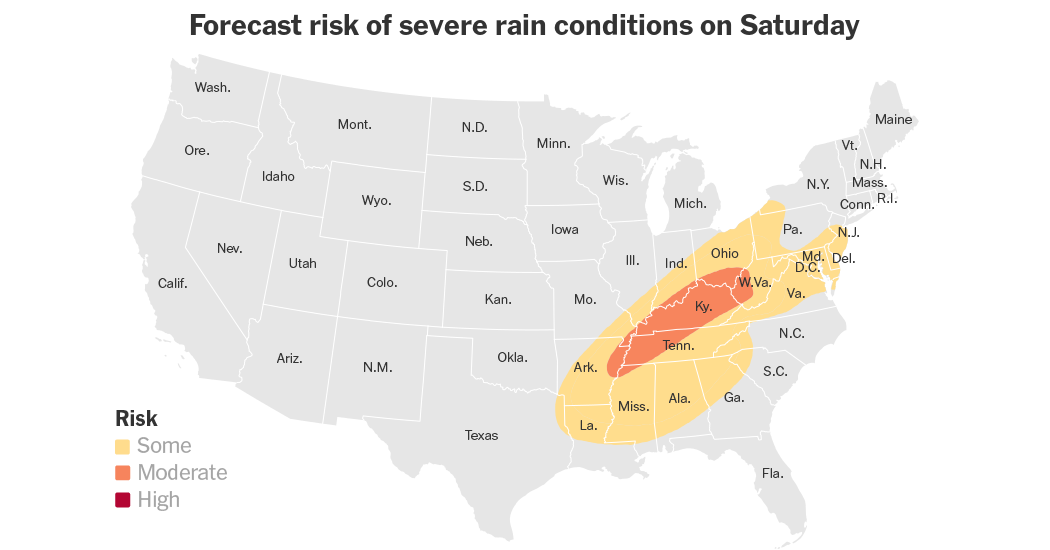
The type of flash flooding that forecasters are expecting, especially in Tennessee and Kentucky, is unusual for this time of year, Alex Lamers, a meteorologist with the Weather Prediction Center, said early Friday morning. By next week, more typical February weather is expected to return.
The rainfall is the rarity of this mid-February storm.
The region most at risk of flooding — including Tennessee and Kentucky — is already sopping wet, with some rivers near or at flood stage after having seen weeks of recent rainfall. This rare amount of moisture surging north is more intense than the rain that has already fallen. And some places, like Lexington, Ky., where three to five inches of rain is forecast, could break their February record for daily rainfall. (Over three inches of rain was measured there on Feb. 13, 1989.)
Forecasters like Mr. Lamers have remained confident that heavy rain and flash flooding will occur across the region Saturday into Saturday night. However, as of Friday morning, they were unsure where exactly the worst of the it would fall during the storm.
As of Friday morning, forecasters predicted that the heaviest rain was likely to fall in western or central Kentucky or northwestern Tennessee. The amount of rain that falls here could be one to two times the normal amount for this time of year.
This may keep the worst of the rain out of cities like Nashville, but flooding may still be a concern.
With the ground already saturated, forecasters in places like Paducah, Ky., are especially concerned by some of the outlier rainfall amounts of up to seven inches. “It won’t take much to produce flooding,” one forecaster there wrote, warning that the region “may have a significant flooding event on our hands.”
Forecasters in the mountainous areas in the eastern regions of the places most at risk for flooding warned that the ground had produced conditions ripe for landslides and debris flows on steep slopes around the area. Forecasters in Charleston, W.Va., reminded residents who live on or at the base of hillsides to watch out for signs of potential ground movement: trees leaning in unusual orientations, or water and mud seeping in where they are not expected.
The warmer, springlike storm will be quick, and winter will return on Monday. Below-average temperatures will plunge across the eastern United States. Snow is likely to return on Tuesday and Wednesday, coating the same areas that may potentially flood this weekend in Tennessee and Kentucky — all as a coastal storm possibly returns heavy snow back to northeast coastal cities.